
One of the most stupendous tasks in the history of science, started 200 years ago by William Lambton and completed four decades later by George Everest, resulted in the Great Indian Arc of the Meridian. It also established that the Himalayas constituted a mountain range and Mount Everest was the highest point on the earth.
TWO HUNDRED years ago, on April 10, 1802, the British surveyor Col. William Lambton began an ambitious, audacious and mathematically meticulous scientific odyssey at St. Thomas Mount in Madras (now Chennai). It took four decades to be completed. The project ended on the foothills of the Himalayas. Lambton carefully laid the baseline, which stretched across a distance of 12 kilometres between St. Thomas Mount and another hillock in the southern direction, for the “measurement of the length of a degree of latitude” along a longitude in the middle of peninsular India.
This 12-km-long horizontal at about sea level grew into what is known as the Great Indian Arc of the Meridian, a gigantic geometric web of ‘triangulations’ roughly along the 78° longitude across the entire length of the subcontinent covering a distance of about 2,400 km in the north-south direction. As a corollary, at the end of this massive and perilous exercise, which consumed “more lives than in most contemporary wars” and involved tomes of calculations and equations more complex than any in the pre-computer age, it was conclusively proved in 1843 that the Himalayas constituted a mountain range that was higher than the Andes, until then believed to be the highest. It also established the height of the highest point on the earth, what is now called Mount Everest.
Lambton had originally planned a short arc. It later grew in size and scale to become “one of the most stupendous works in the history of science”, one of the greatest human endeavours ever undertaken. It involved, among other difficult aspects of the relentless journey of scientific discovery, moving across the subcontinent with diverse measuring instruments and other paraphernalia, including the massive 36-inch theodolite which weighed over half a tonne, to be carried by as many as 12 men to be placed at vantage points – from the tops of temple gopurams to 30-metre high bamboo structures – from where the crucial measurements of angles were made. The Great Arc became the longest measurement of the earth’s surface ever to have been attempted.
William Lambton’s genius had conceived the idea of the Great Trigonometrical Survey (GTS) of the country with the Great Arc providing the skeletal framework for it. But he died to the cause at the age of 70, midway through his task, while surveying at a place called Hinganghat in Maharashtra, where is situated his uncared-for grave, today no more than a flat, weathered and battered piece of stone. The Great Arc was completed by George Everest, after whom the highest point on the earth is named.
The measurement of the Great Arc resulted in new values for the curvature of the earth throwing fresh light on the then longstanding debate on the exact shape of the planet. Actually, it was these unsettled fundamental scientific issues that drove Lambton to undertake this mammoth task rather than the more direct applications – especially from the perspective of the expanding British empire – of the countrywide survey in cartography and production of accurate topographic and revenue maps.
The GTS was not the first survey of the country. Lord Robert Clive of the East India Company had raised a mapping agency, which later became the Survey of India, and commissioned the Bengal Surveys as early as 1767 under Major James Rennel. This is regarded as the beginning of systematic topographical mapping in India and the founding of one of the oldest survey and mapping agencies in the world. In 1799, after Mysore was brought under the control of the British, the third Mysore Surveys were ordered under Col. Lambton, to define and defend the newly acquired territory.
Lambton was part engineer, part mathematician and astronomer, but his passion was geodesy, the study of the earth’s shape. He had read advanced books on mathematics and astronomy during his term as a prisoner during the American War of Independence. After his release he was deployed to assist in the survey of the New Brunswick area, which was carried out to delineate the boundary between British Canada and the United States. He later joined the British Army and was posted to India in 1796, when he took part in the Fourth Anglo-Mysore War.
At that time, detailed knowledge of the earth’s size and shape did not exist. Although the fact that the earth was not a true sphere but more curved at the Equator and flatter at the poles had been established about 70 years earlier, a precise determination of exactly ‘how much flatter’ or more curved, remained an outstanding issue for the scientific community. The length of the arc of a degree of latitude is a measure of the curvature of the earth at that point. In the 1730s, two expeditions had been sent out from France, one to the Equator in what is now Ecuador and the other to the Arctic Circle in Lapland, to measure the length of a degree of latitude by ‘triangulating’ north and south from a carefully measured baseline so as to cover a short arc of about 300 km. By determining the exact positions (in terms of latitude and longitude) of the arc’s extremities by astronomical observations of fixed stars, the value of one degree of latitude was obtained. The length of a degree in Ecuador had turned out to be a kilometre shorter than that in Lapland, indicating that the parallels at the Equator were bunched closer than at the poles and the earth was determined to be an ‘oblate’ spheroid.
THERE still remained the question of how oblate the spheroid was and whether this flattening was of a regular or consistent nature. Exercises in triangulations were being undertaken in France and in Britain and attempts were made to link the two series of triangulations across the English Channel. Lambton now had the idea of doing the same thing in the tropical latitudes, roughly midway between the Equator and northern Europe. In the East India Company’s need to define, defend and exploit its newly conquered areas, Lambton saw expedient means of answering the outstanding scientific questions in geodesy.
By playing down the elements of scientific research and stressing the practical value of “ascertaining the correct positions of the principal geographical points (within Mysore) upon correct mathematical principles”, Lambton proposed in November 1799 a scheme for a ‘Mathematical and Geographical Survey’ based on a north-south series of triangulations which could later be ‘continued to an almost unlimited extent in every other direction’ and could yield such information as the precise width of the peninsula. He essentially proposed a framework – the primary triangulation in the north-south direction – the sides of whose triangles could serve as the bases for different local surveys and networks of secondary triangulations that would cover the entire country, instead of local surveys having to measure their own baselines. The principal geographical points of his series could also correct the often doubtful orientations of existing local surveys.
The technique of ‘triangulation’ involves identifying three mutually visible reference points, usually prominent hills or buildings, as the corners of a triangle. Knowing the exact distance between two of these points, and then measuring the angles made at each by the respective lines of sight with the third reference point, the distance and position of the third point can be deduced by simple trigonometry. One of the newly determined sides of this triangle would now serve as the baseline for a second triangle that will include a new reference point whose position would, in turn, be established by the same procedure. Another triangle is thus completed, which serves the basis for yet another new triangle and so on. A chain of triangles thus results.
In early 1800, Lambton’s proposal for the Third Mysore Survey was approved. For what was described as the ‘trigonometrical survey of the peninsula’, Lambton had first to determine a working value for the length of a degree of latitude in mid-peninsula for which he planned a short arc in the vicinity of Madras. But he could begin only in April 1802: it took two years for a suitable ‘theodolite’, required for the crucial measurements of the angles of his primary triangles, to arrive from Britain.
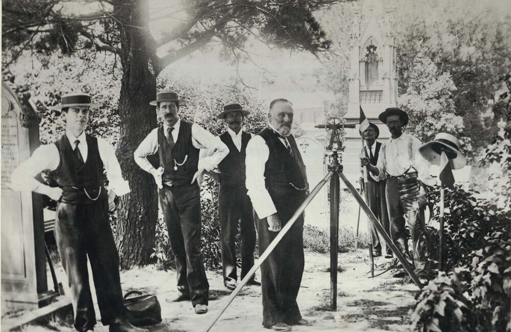
A theodolite, then a key instrument of a surveyor, is essentially a telescope mounted on an elaborate structure so that it pivots both vertically about an upright ring or ‘circle’ and horizontally about a larger horizontal circle. This enables the angle of elevation as well as angles in a plane to be read off the instrument’s calibrated circles. Plummets, spirit levels and adjustment screws in the instrument allow its alignment and levelling and micrometers and microscopes enable reading the calibrations. Further, the whole thing has to be rock steady and its engineering optics and calibration have to be of the highest precision. When Lambton undertook his mission, in the world there were perhaps two or three instruments of sufficient accuracy and sophistication. Lambton could locate one in Britain, built by the famed manufacturer William Cary who had built a similar instrument for an elaborate British Survey undertaken by Wiliam Roy.
For baseline measurement, a steel measurement chain of high quality was located in Calcutta (now Kolkata). Along with a large Zenith Sector (for astronomical observation) and other instruments, the chain was apparently intended for the Emperor of China but for political and other reasons its journey was cut short in Calcutta. Lambton bought the instruments. The chain consisted of 40 bars of blistered steel, each two and a half feet long and linked to the next with a finely wrought brass hinge. The whole contraption could be folded up to fit neatly into a teakwood chest.
So, on April 10, 1802, Lambton laid out the first baseline which would also serve as the sheet anchor for the Great Trigonometrical Survey of India. To measure the full 7.5 miles (12 km) of the baseline with his 100-foot chain, Lambton had to make 400 individual measurements with the chain. At each measurement, the fully extended chain was supported and kept taut inside five wooden coffers, each 20 ft long. These were propped up with tripods fitted with elevating screws for levelling. Each coffer was fitted with a thermometer to record the temperature at the time of measurement so that the expansion of the bars due to temperature variations could be accounted for. This was done by comparing with a similar chain obtained from Britain but kept in a cool vault. The measurement of the first baseline took 57 days.
In late September, Lambton began his triangulation. He took angles from his baseline to pre-selected points to the south and the west with his 36-inch Great Theodolite. He completed the short meridional arc from Madras to Cuddalore, observing latitudes at both ends, to determine the length of a degree that was essential for his work. This short southern series of triangles down the coast took about a year. In October 1804, Lambton headed westward and inland and carried his triangles towards Bangalore.
The original plan of using the small hillocks which dotted the landscape (known as doorg in the local language) as reference points for the westward chain of triangles posed unforeseen problems – many of them were guarded by local chieftains who refused access to its tops. This forced Lambton to realign the chain’s northern edge, but once further west of Bangalore he apparently did not face this problem and the progression, in fact, yielded the largest triangle yet measured. Lambton’s first longitudinal arc right across the peninsula (as against the north-south latitudinal arc) yielded a surprising discovery. The measurement revealed that the peninsula had apparently shrunk. Against the value of about 400 miles of the then current maps, which were based on coastal surveys and astronomical references, Lambton’s triangles showed that it was only 360 miles from Madras to Mangalore.
With the onset of the monsoon in 1805, Lambton returned to Bangalore to embark on his original mission – the latitudinal measurement or the Great Arc of the Meridian. With the Bangalore base as its starting point, the triangles of Lambton’s Great Arc extended north about 100 miles up to where the independent territory of the Nizam of Hyderabad lay, and then south towards Cape Comorin (Kanyakumari), the tip of the subcontinent.
Lambton’s Great Theodolite weighed half a tonne. Severely damaged on various occasions, it was rebuilt and is now in the Survey of India’s headquarters in Dehra Dun.
The next baseline was measured in Coimbatore in 1806. To get an idea of the accuracy of Lambton’s measurements, it may be mentioned here that, in its length of over six miles, the difference between the triangulated measurement carried from Bangalore along the Great Arc and the actual measurement at Coimbatore was only 7.6 inches. From Coimbatore, the big stride along the Great Arc to Cape Comorin – with an equally accurate baseline check at Tirunelveli – was completed successfully in 1809.
By 1815, Lambton had covered the whole peninsula south of the river Kistna (Krishna), which resulted in the measurement of the longest geodetic arc closest to the Equator, from Cape Comorin to the 18th Parallel.
But this journey was marred by an accident at Thanjavur in late 1808 when Lambton moved away from the Giant Arc to carry out a parallel triangulation further down the east cost. While trying to hoist the half-tone theodolite atop the 217-ft gopuram of the Brihadeeshwarar temple for his angle measurements, the guy that was lifting the theodolite snapped and the instrument crashed down into a mangled mass of steel and iron. Lambton was not one who would give up so easily, nor would he wait for a couple of years for a new instrument to arrive – though he, accepting full responsibility for the mishap, had ordered a new one at his own expense. According to an account of the Great Arc, Lambton shut himself up in a survey tent for nearly six weeks and repaired it himself with help from the military workshop at Tiruchi. Lambton, more than anyone else, was aware of the possible errors in the repaired instrument, but checks on measurements revealed that discrepancies were marginal.
Repeating and reviewing measurements was an integral part of the Great Arc measurement. For example, the length of a degree of latitude as calculated from the short arc from Madras in 1802 was soon revised when the Great Arc produced a more refined value. Correspondingly, the earliest triangles based on the Madras measurement had also to be revised. As the arc got longer, the parameters associated with the curvature of the earth were recalculated. Isaac Newton’s value for the compression of the earth at the poles was 1/230. It was revised down to 1/304 in 1812 and by Lambton himself to 1/310 in 1818.
In 1818, Lt. George Everest joined Lambton, and with his help the Nizam was convinced to permit Lambton’s passage further north. As the Great Arc progressed beyond the territories under the control of the Madras government, Lambton’s survey was transferred to the supreme government in Calcutta and the survey, until now variously called, was officially named the Great Trigonometrical Survey (GTS) of India. In 1818 it was hoped that the survey would continue north, east and west, at least until lateral triangulations could link Calcutta and Bombay.
Lambton planned to continue on the same 78° meridian from Hyderabad to Nagpur in central India. But he died at the age of 70 in 1823, before he could fulfil his dream. Of all his contributions, the greatest contribution is the measurement of the meridional arcs, the results of which were employed well into the 20th century in all investigations of the figure of the earth.
Lambton’s mantle fell on Everest’s shoulders. Everest, however, wanted to improve upon Lambton’s work by basing the surveys on a rigid reference framework. This raised the problem of finding a suitable reference spheroid to fit the shape of the earth’s ‘gravitational equipotential surface’ for India and the adjacent countries. From Kalianpur in Madhya Pradesh, more or less the centre of India, Everest conceived covering the length and breadth of the country by a ‘gridiron’ of triangular chains, as against a network of triangulations as conceived by Lambton. He redesigned the 36-inch Great Theodolite. He replaced the steel chain with 10-ft compensation bars. He completed the Great Arc up to Banog, in the first Himalayan range, near Mussoorie, a length of 2,400 km.
Everest made the government agree to a revision of Lambton’s measurements based on more accurate instruments and procedures laid down by him. Later, in 1830, he was appointed the Surveyor General of India but, much against the wishes of the government, which wanted the Survey to focus on the needs of the expanding Empire’s infrastructural needs, Everest continued to devote much time to the Great Arc. This task was completed by him (together with Lambton’s associates) in the year 1841, and he took two more years for computations and adjustments. The work and norms laid down by Everest have stood the test of time. The Everest Spheroid, the geodetic datum of reference for the Indian region, evolved by him in 1830, is still used in India (albeit with revisions), Pakistan, Nepal, Myanmar, Sri Lanka, Bhutan and other South Asian countries. Based on his concept, the gridiron network now covers all of India and forms a solid foundation for accurate surveys and mapping for defense and other developmental needs.
It was with the help of the gridiron network that the highest peak of the world was observed and identified in 1852 and its height declared as 29,002 ft (8,840 m). After fresh observations and computations, the Survey of India declared its height in 1954 as 8,848 m. In 1975, China put a metallic beacon on Mt. Everest and observed it from nine stations, and the height was declared to be 8,848.13 plus or minus 0.35 m.
The significance of Lambton’s and Everest’s work can be gauged from the fact that they worked at a time when there was no modern communication network. The country was marked by jungles, wild animals, hostile weather conditions, mighty rivers, swamps and floods and infectious diseases, particularly malaria. The average length of a side of a triangulation was 31 miles, the maximum being 62 miles. One cannot imagine how such long-distance measurements were planned, laid down on the ground, and the line of sight cleared of trees and sometimes even houses and other structures. If Lambton went on relentlessly on his journey despite itinerant fever and other ailments like dysentery, Everest did all this despite poor health.
TODAY, the Survey of India in its post-Independence phase has consolidated the work of Lambton-Everest, built upon it and mapped the entire country on 1:50,000 scale and about 40 per cent of it on 1:25,000 scale. With advances in instrumentation, measurement and the advent of digital technology, the Survey of India is at present in the process of digitizing the existing topographic data on 1:50,000 scale.
Alongside, an effort is being made to enable free public access to topographic data – analogue as well as digital – without the prevalent security and defense-related restrictions on access. For this a mammoth exercise has been undertaken to map the geographic control points on a different geodetic datum called WGS-84 instead of the Everest Spheroid, using satellite-based Global Positioning System (GPS) surveying techniques. While some digital topographic maps of southern India on 1:250,000 scale on WGS-84 should become available in the next three to four months, the mapping of the WGS-84 control points is expected to take three to four years and digitized topographic maps of the entire country are expected to be available for public access in seven to eight years.
This is the mandate of the newly conceptualized National Spatial Data Infrastructure (NSDI), a joint effort of the Department of Science and Technology (DST) under which the Survey of India functions, and the Departments of Space and Defense. The NSDI is expected to be launched formally on August 15, 2002. Since all this was made possible because of the pioneering efforts of Lambton and Everest in their gigantic work on the Great Arc, the Survey of India has rightly launched a year-long celebration of 200 years of the Great Arc, which got under way in Delhi with a map-based treasure hunt for schoolchildren. This is to be followed by year-long bicentennial celebrations, which will include international conferences and workshops.